|
GIS INSTITUTE
|
Live Projects for Engineering Final
and Pre-Final Year Students

|
|
|

Micro Solutions pioneered the GIS training in Eastern India in the year 2001. It got the affiliation with Webel subsequently and formed Webel GIS
Academy.The GIS Academy is a learning and performance center dedicated
to GIS and developed for the clients and students benefit.
Through the GIS Academy we elevate our client and end-users towards self-sufficiency and greater professional gains. Internally, it is tasked to train GIS personnel to further their capability to train clients and colleagues better It is also aimed to pursue a career development program where GIS personnel learn managerial and soft skills such as project management, customer service, communications skills, etc.
Through the GIS Academy, and together with our clients, we seek to gain a formidable team with a collective broad knowledge and collectively and deep expertise individually to take care of the software investment in place.
Webel GIS Academy is an initiative of Webel Informatics Ltd., the IT Education & Training arm of West Bengal Electronics Industry Development Corporation Limited [Webel] and Micro Solutions. a professional GIS organisation with past experience of undertaking challenging GIS project assignments.
GIS is a collection of computer hardware & geographical data for capturing, managing, analysing & displaying all forms of geographically referenced information.
GIS IS ONE OF THE MOST SOUGHT AFTER CAREERS IN TODAY’S WORLD OF INFORMATION TECNOLOGY.
|
|
|
|
|
|
|
|
|
|
|
|
 Facilities
|
-
Component & Committed Faculties for both Entry & Higher Level
-
All PC s Connected in LAN for easy access
-
Placement Assistance online
-
24 Hrs. Available Broadband
-
Air – Conditioned Class Rooms
-
High End Graphics & Multi Layer Mapping
|
|
|
|
|
|
|
|
COURSE CURRICULUM |
|
|
|
|
|
|
COURSES
|
|
SESSIONS |
|
|
1. |
Course A
|
|
10 |
|
|
|
|
|
|
|
|
2. |
Course B
-
INTRODUCTION TO GIS
-
BASICS OF VARIOUS GIS SOFTWARES
-
REGISTRATION, DIGITIZATION & DATA ATTACHMENT
|
|
|
20 |
|
|
3. |
Course C
-
INTRODUCTION TO GIS
-
BASICS OF VARIOUS GIS SOFTWARES
-
SCANNING, REGISTRATION, DIGITIZATION & DATA ATTACHMENT
-
THEMATIC & RELATIONAL MAPPING
-
GEOCODING, REDRISTICTING, BUFFERING ON A SINGLE SPECIALISE AND POPULAR GIS PLATFORM.
|
|
|
30 |
|
|
4. |
Course D
-
INTRODUCTION TO GIS
-
BASICS OF VARIOUS GIS SOFTWARES
-
SCANNING, REGISTRATION, DIGITIZATION & DATA ATTACHMENT
-
THEMATIC & RELATIONAL MAPPING
-
GEOCODING, REDRISTICTING, BUFFERING, TRANSLATING ON MULTIPLE SPECIALISE AND POPULAR GIS PLATFORMS INTER-PLATFORM TRANSFER OF DATA.
|
|
|
40 |
|
|
5. |
Course E
-
DESKTOP MAP MAKING
-
PREPRESS APPLICATION
-
GIS
|
|
|
50 |
|
|
6. |
Course F
-
INTRODUCTION TO GIS
-
BASICS OF VARIOUS GIS SOFTWARE
-
REGISTRATION, DIGITIZATION & DATA ATTACHMENT
-
REMOTE SENSING & PHOTOGRAMMETRY
-
IMAGE PROCESSING & INTERPRETATION
|
|
|
50 |
|
|
7 |
Course G NEW COURSE FOR CIVIL ENGINEERS
-
TRAIN YOURSELF IN
-
REAL LIFE TOTAL STATION ELECTRONIC SURVEY
-
HIGH END DIGITAL MAPPING
-
GEOGRAPHICAL INFORMATION SYSTEM
-
CAD AND ELEVATION MODELING
|
|
|
35 |
|
|
|
-
ADDITIONAL COACHING FOR
-
COMMUNICATION SKILL
-
COMPUTER BASICS
-
PRESENTATION
-
MOCK INTERVIEWS
|
|
15 |
|
|
8. |
Course H
-
DIPLOMA IN REMOTE SENSING & GIS
|
|
|
100 |
|
|
|
|
|
|
|
|
|
Note 1: For Project Guidance add 10 sessions for courses C, D, E & F and dissertation project for Course no. 6 add 15 sessions on job training for 6 weeks is applicable for Course no.8. Stipends and Scholarships applicable for course no.8 during on job training depending on performance.
Note 2: For beginners who do not have Computer overview, Completion of Course A is mandatory for attending subsequent courses. |
|
|
 |
|
|
|
|
|
|
|
|
|
|
|
|
The Support Team and Joint projects |
|
|
Experienced, well-trained and certified consultants and researchers who desire to soften the hardship of the project collaborate often with our Customer Support Group. Total Customer Experience at GIS includes major activities aimed at customer satisfaction. Slowly this is becoming an umbrella organisation to foster collaborative research, training and eLearning in Geographical Information Systems (GIS).
Developing joint research in the following areas:
-
GIS in the study of air and water pollution and quality: collaborator -University of Calcutta
-
Micro watershed area formation in declared arid zones: collaborator-Kalyan
-
Agro-forestation: collaborator-Bhalopahar
-
Visualization and virtual reality in security surveillance: collaborator – National Investigation and Security
-
Industry specific maintenance and production scheduling: collaborator - National Investigation and Security
-
Public Participation & Development studies: collaborator- University of Calcutta
-
Ocean and coastal GIS: collaborator-Help Tourism
-
Medicine and health: collaborator-Sampan and KMDA
-
E-Route Directory of Greater Kolkata: collaborator-Katokatha
|
Our offered services include recover, produce and edit any kind of engineering and architectural drawings and maps [cadastral land base, facility and distribution networks maps, satellite image interpreted maps]
Our quality procedures involve multiple cross-check of electronic files against source documents and utilization of automated quality tools & routines.
We undertake survey jobs and blend the classical survey method with e-Survey and produce state of the art e-Maps with layered information.
We essentially consider GIS activity to be multidisciplinary and faculties from different branch of engineering to comprehensively conclude a project.
|
|
|
|
|
|
Project Features & Competence |
|
|
|
|
|
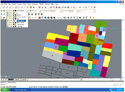
Cadastral Map Making |
|
 |
|
|
Vectorization of maps (in TIFF format) was performed as per customer specifications.
Multiple layers such as Area Boundaries, Buildings, Drains, Lamp posts, Shops, Plots, Embankments, Railways, Text, Topology, Rivers, and Water bodies are formed. Each property can be linked with Database. |
|
|
|
|
|
|
|
|
|
|
|
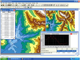
Digital Elevation Models |
|
.jpg) |
|
|
Based on the spot heights of the area surveyed, the digital maps are formed. This consists of a sampled array of elevations for a number of ground positions at regularly spaced intervals. The spot heights are utilized to generate Digital Elevation Model.
This helps to represent cartographic information in a methodical form enabling interpreters to perform slope analysis. Each point can be linked to Database. |
|
|
|
|
|
|
|
|
|
|
|
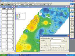
Contour Maps and Profile |
|
 |
|
|
A variety of landmark and landscape information can be depicted by contour maps.This is in contrast to older cadastral surveys, which primarily show property and governmental boundaries.
Contour Maps can be in 3 D layers and profile of a selected cross section can be represented graphically.Necessary supportware is provided for projection of flood zone,buffering zone,evacuation area. A comprhensive disaster management project consultancy can be offered. |
|
|
|
|
|
|
|
|
|
|
|
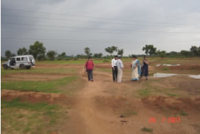
e-Survey and e-Mapping |
|
 |
|
|
Micro Solutions is geared up to accept challenging assignments of e-Survey and e- Mapping. The essential inputs are collected documented from the client specification and available archives and then compared with the surveyed parameters both in CAD and GRAPHICS platforms.
The survey methodology also ensures to determine how support systems and procedures for staff could be further developed to enable the client or users to make the most effective and appropriate use of learning technologies to enhance the student and staff experience. |
|
|
All necessary and important state of the art gadgets are employed for e Survey and e Mapping. Micro Solutions provides the support to the client for:
-
GIS standards and compliances
-
Real time integration and presentation of distributed spatial data sources
-
Inexpensive web map application development
-
Flexibility and future upgradability
|
|
|
|
|
|
|
|
|
|
GIS enabled PLC- SCADA |
|
|
|
Being a support ware organization Micro Solutions since its inception had been trying to integrate the strength of multiple faculties involved at the time of inception. The engineering and automation knowledge available with the organization today can enable integration in the field of Real Time GIS and SCADA. [Supervisory Control And Data Acquisition]
The GIS platform can be used as the Front End and the Industrial SCADA can perform the zonal depictions with real time integration.
For Real time integration in GIS, PLCs can be used for real time data capture. In such case the real time data in coalition with real life space information [Geo referenced data] could be an ideal situation for disaster management packages. |
|
|
|
|
|
|
|
|
|
|
|
On Line Security Surveillance |
|
|
|
Micro Solutions has innovated the concept of using GIS as the front end of On Line Security Surveillance projects. A pilot project has been made in house to map the security susceptible areas with geo-referenced data and manipulated time scale so that the time base can be changed and the susceptibility can be viewed with respect to viewable space and time base. |
|
|
|
|
|
|
|
|
|
|
|
Industry Resource Planning |
|
|
|
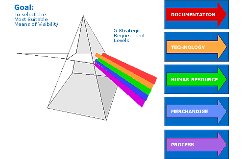
The in-depth domain knowledge in multiple GIS software has enabled the professionals of Micro Solutions to develop the support ware towards Industry Resource Planning using GIS. The search engine is basically a GIS platform that spatially depicts various dpartments of a corporate or a plant or a process. The documentation related to various functions are linked in the most user-friendly fashion for resource planning.
-
Facilitates company-wide integrated information systems, covering all functional areas
-
Presents visibility of core Corporate and Engineering activities and reduces downtime by depicting instantly the relevant information both off and on line
|
Feature
-
Full screen Drawings
-
Dynamic zoom by mouse wheel
-
Define your own zoom levels
-
Powerful search function over all attribute data
-
Lists: zoom to object by mouse click
-
Display, hide and move overview map, legend, search window
-
Integration of GPS Photo Mapper functionality
-
Patch update
|
|
|
|
|
|
For Management – to know what is happening in the company
|
|
|
|
One solution for better Management
|
|
|
|
For cycle time reduction
|
|
|
|
To achieve cost control & low working capital
|
|
|
|
To marry latest technologies
|
|
|
|
To shun the geographical gaps
|
|
|
|
To satisfy the customers with high expectations
|
|
|
|
To be Competitive & for survival
|
|
|
|
To pinpoint the failure
|
|
|
|
To identify the history and B.O.Q instantly
|
|
|
|
Simultaneous visibility of Engineering and commercial attributes
-
Generalized approach
-
Same module can be used for MIS /Engineering and Maintenance functions
-
Effective parametric and layer wise viewing of information as the kernel is GIS embedded
-
No lead time requirement for software development
-
Tuned for more users/networks with adequate & in- built security
-
Parameterized for flexibility
-
Can sit on latest hardware & software platforms
|
|
Phases 1. Product Selection 2.Preparations 3.Production 4.Implementation 5.Post-Implementation
|
|
Industry Resource Planning: Objective
|
|
|
|
|
|
 |
|
|
|
|
|
|
|
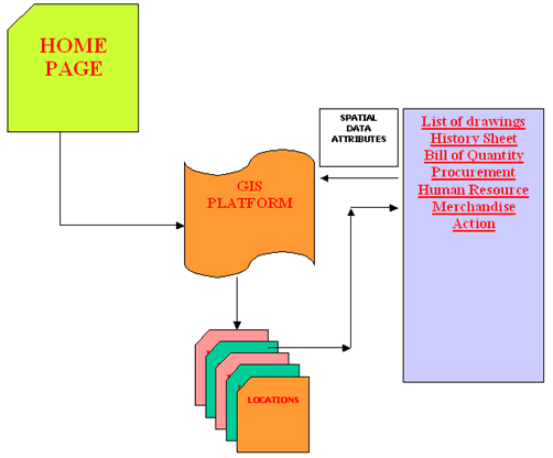
Industry Resource Planning: Document Structure
|
|
|
|
|
|
 |
|
|
|
|
|
|
|
Industry Resource Planning: Back Plane
|
|
|
|
|
|
.gif) |
|
|
|
|
|
|
|
|
|
|

|
GIS INSTITUTE |